Property Map Treasure Hunts: Finding the Places Your Ancestors Lived
One of the many wonders of Google Maps is the ability to travel down many streets and roads via “Street View.” And then of course there is aerial view that allows you to locate your ancestors properties of a bygone area by comparing old Platt and Ownership Maps with current ones. I am always amazed I don’t see more people doing this. Roberts Estes who writes one of my favorite blogs DNA Explained is a shining exception. There are several things required to do this but none are that difficult. If the ancestors you are hunting appear on a census from 1850 or later (and sometimes before that) you are likely to find a community, a township or a post office they lived near listed on the census. If it is 1900 or more recently you may find an actual street address. Sometimes you need to go back or forward a page to see the street name usually written vertically in the first column. Here’s an example from the 1920 Census for San Francisco, California for my great grandparents Frank S & Lulu P Mosier at 1435 Oak Street.


Another source of actual physical address in 20th century is City Directories. Sometimes you may have a photo or letter with an address as well.
What if all we know is the township they lived in? Well that is going to be a bit trickier but certainly worth the work if you are successful. Some old land ownership maps are fairly obscure and hard to find but it is always worth and internet search using the Township and county as many of these are available on line. In England there are Tithe Maps which can be quite helpful and in America we have the historic Sanborn Fire Maps. Among my favorites are the County Land Ownership Atlases. There are many places to look for these from Historical Societies to subscription services like Ancestry or MyHeritage to free services like FamilySearch. But there are other places you should check. The Library of Congress Map Collection , New York Public Library Map Collection, David Rumsey Historical Map Collection, The Harvard Library Map Collection, The Perry-Castañeda Library Map Collection, Norman B. Leventhal Map Center of the Boston Public Library and last but not least the US Bureau of Land Management which includes Land Patents, plat books etc for the west, Midwest and some of the South (including exact section locations within a township or county). Please note that Map collections often include places well outside where you might think. Just because the Collection is in Texas doesn’t mean they do not have Maps across the globe.
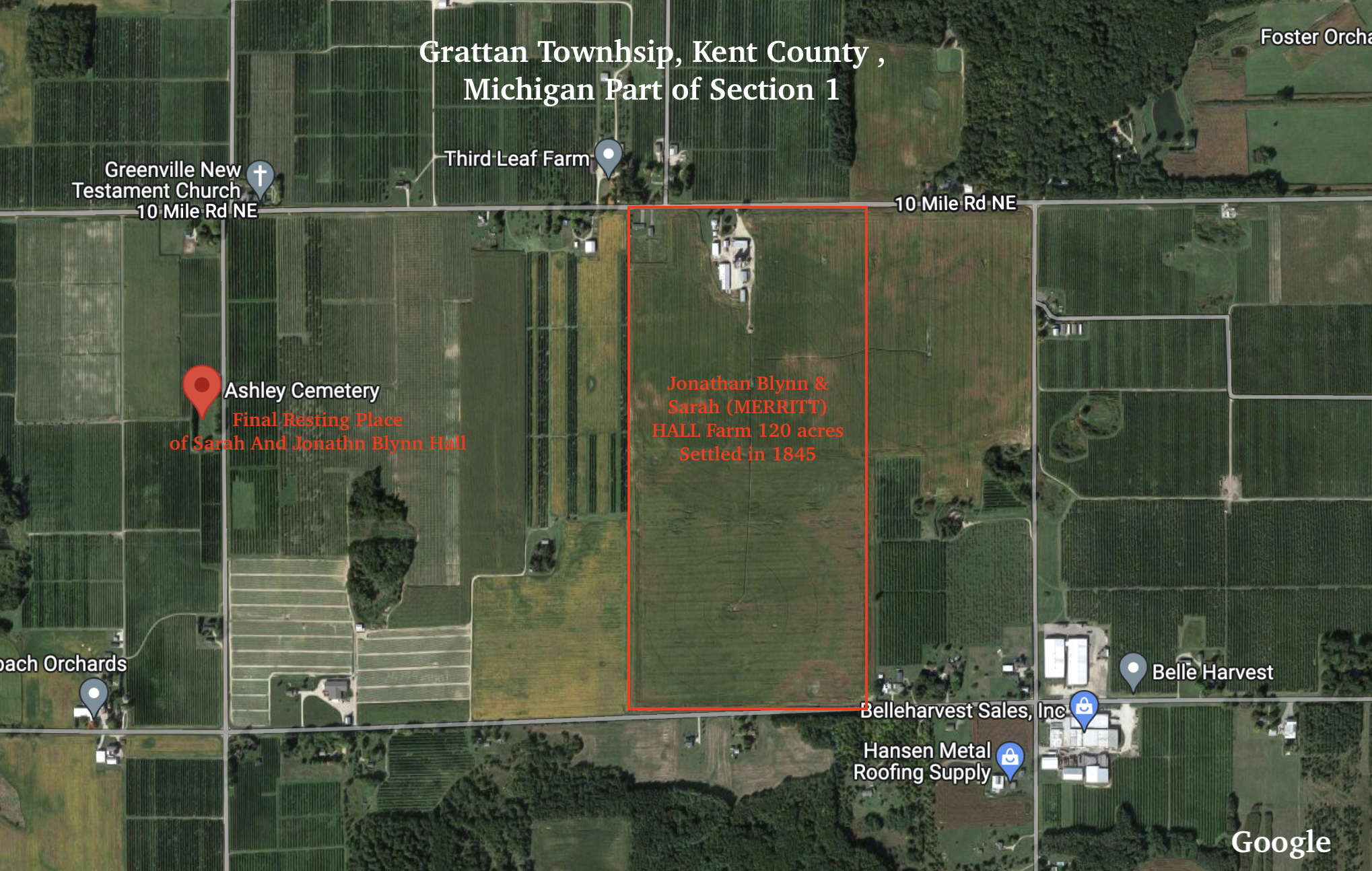
So let’s look at a couple of recent ones, that I just uncovered. My 2nd great grandfather Jonathan Blynn HALL according to The History Of Kent County Michigan came to Kent County in June of 1844 purchased land there and then returned to his native Middlebury, Genesee County (now Wyoming) New York where he married my 2nd great grandmother Sarah Jane MERRITT the first of January 1845. They settled in Grattan Township, Kent County Michigan. We can locate their farm on the 1894 Land Ownership Map as seen here:
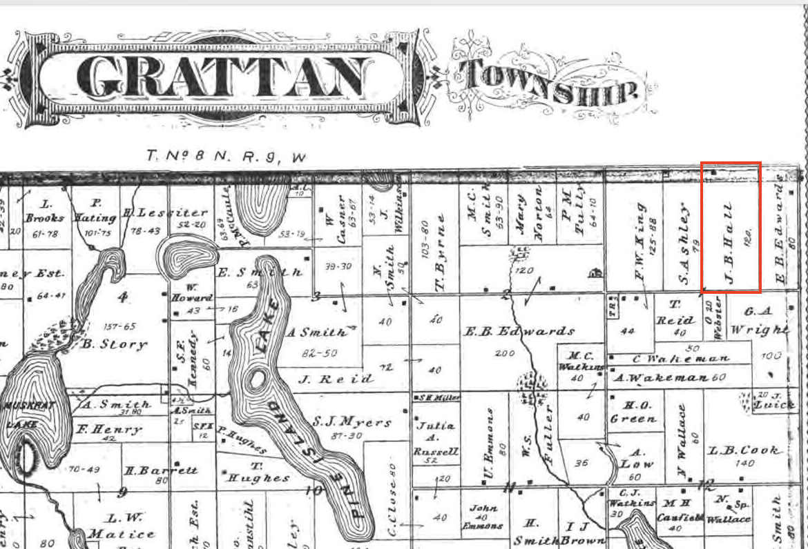
This particular map is quite helpful since it has many lakes that make the locating easier. Although I have zoomed in here doing a search on Google for Grattan Township located the top right corner which made this easy. What is fascinating here is how close the cemetery is to the family farm.
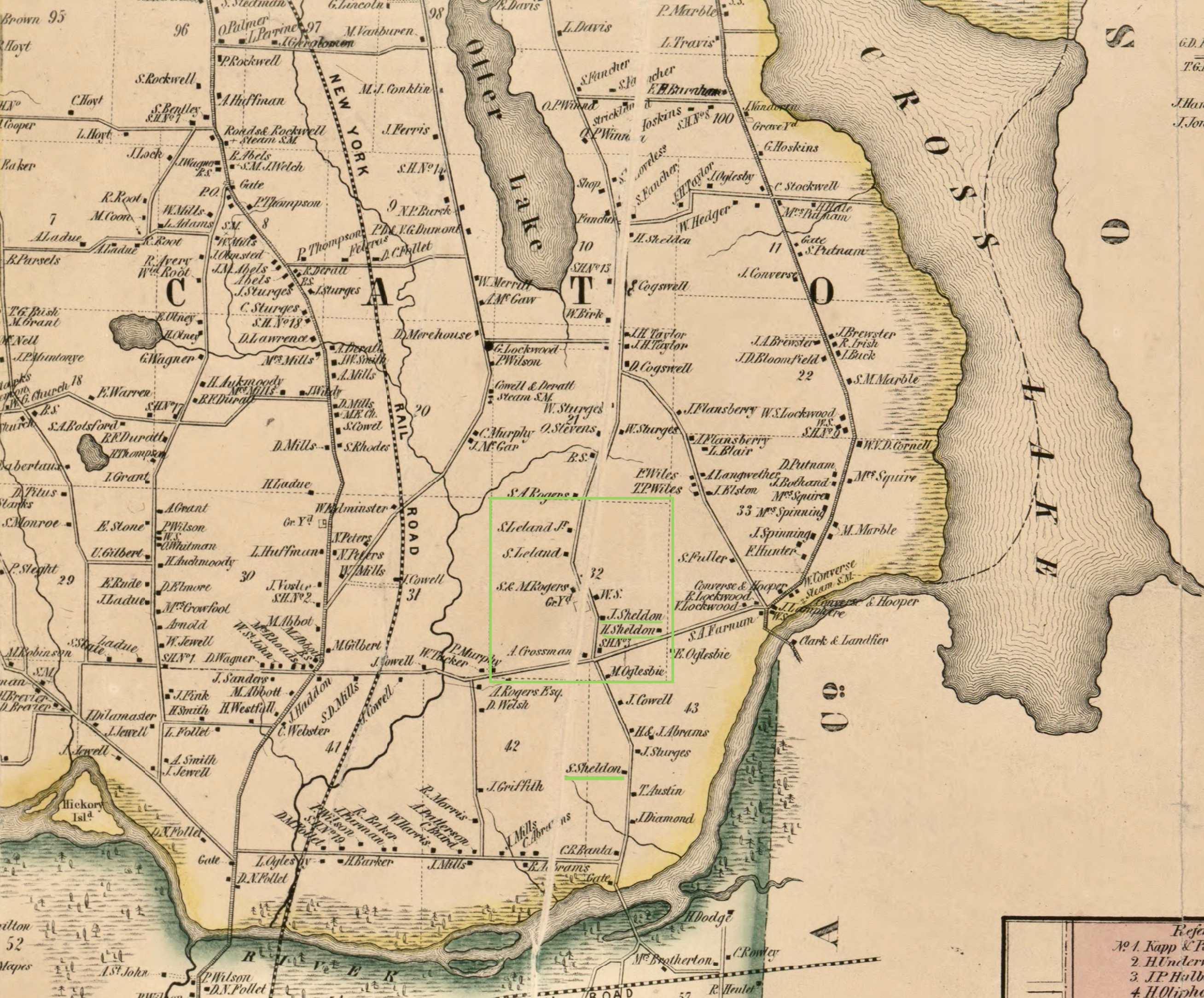
The proximity to the family’s final resting place is probably a clue for many to the proximity to which they lived. My cousin visited the cemetery where our Sheldon’s are buried in Cato, Cayuga, New York never knowing that the family farm was nearly across the road. See map at top of this post. Note the graveyard (Crossman Cemetery) and then Justus Sheldon’s Farm across the road. Here is the Google version.

Now sometimes it is much more difficult the farther back in time we go. I have spent months trying to locate the original plot of Robert WHEATON in the 1643 Division of lands of Rehoboth, MA (originally Seacunke). The original map looks like this:

Robert Wheaton’s 6 acre lot is now located off Greenwood Avenue in what is now Rumford, Rhode Island. In working with archivists at the Carpenter Museum in Rehoboth and the Hunt House Museum in Rumford it is still a bit squishy where exactly his lot was because the old map does not conform to current reality. Sometimes we can just get close and not arrive precisely. Rivers, roads and other land contours can and do change. This may not be precise but it is fairly close. My best guestimate is Robert Wheaton’s lot was between what is now Huntington Drive and Berwick Place. Most likely between Huntington Drive and Haywood Place. The south edge of the lots originally was the Ten Mile River (crossing what is the current Agawan Hunt Golf course). (I am still going to work on this and it may be a future blog post.)

Also note that some of the Map sites include modern overlays—so they superimpose the modern map over the old one. Most have a slider where you can adjust the degree of opacity-transparency. Here is a small example below of a map from Essex County, New York. The gray portions are the old map and the Green and yellow are the current roads etc.

Where to look for ANCESTOR LOCATIONS
- Old letters
- Old Photographs
- City Directories
- Census records
- Land Records
- Probate Records
- Historical or Genealogical Organizations
MAP RESOURCES
- Sanborn Fire Maps
- The Library of Congress Map Collection
- New York Public Library Map Collection
- David Rumsey Historical Map Collection
- The Harvard Library Map Collection
- The Perry-Castañeda Library Map Collection
- Norman B. Leventhal Map Center of the Boston Public Library
- US Bureau of Land Management
A must is Understanding Land Descriptions
Have fun! It isn’t always possible to find out where your ancestors lived but it’s almost always worth a try.
Kelly Wheaton © 2022 – All RIghts Reserved

Thank you for the useful links!
You are most welcome!
This post made my day! I thought I was the only one who was a map nut and liked to “see” the places where ancestors lived even if it doesn’t exist in the present. I do this all the time. One of my great-grandmothers had a house that is now basically under a highway exchange in Wichita Falls, Texas. I was told that after my mother’s baby brother died at the age of one year old, my great-grandmother would take her hoe and hike up the hill to his little grave to tend to it. The cemetery and family graves are still there and she is even buried up there, but the house is long gone and only lives in my imagination.
Yes, there may be many of us. And what is better than actually walking in the footsteps of our ancestors.
Pingback: Best of the Genea-Blogs - 28 August to 3 September 2022 - Search My Tribe News
Pingback: Friday’s Family History Finds | Empty Branches on the Family Tree