Old Rehoboth, Massachusetts & the Ring of Green: Mapping the Past on Greenwood Ave, East Providence, Rhode Island
Background
Two years ago in the lead up to visiting Rehoboth and Swansea, Massachusetts I contacted the East Providence Historical Society and I asked for help in locating the original home lot of Robert WHEATON on the Ring of Green. Sandra Turgeon and I exchanged emails and arranged to meet at the East Providence Historical Society at Hunt’s Mills.

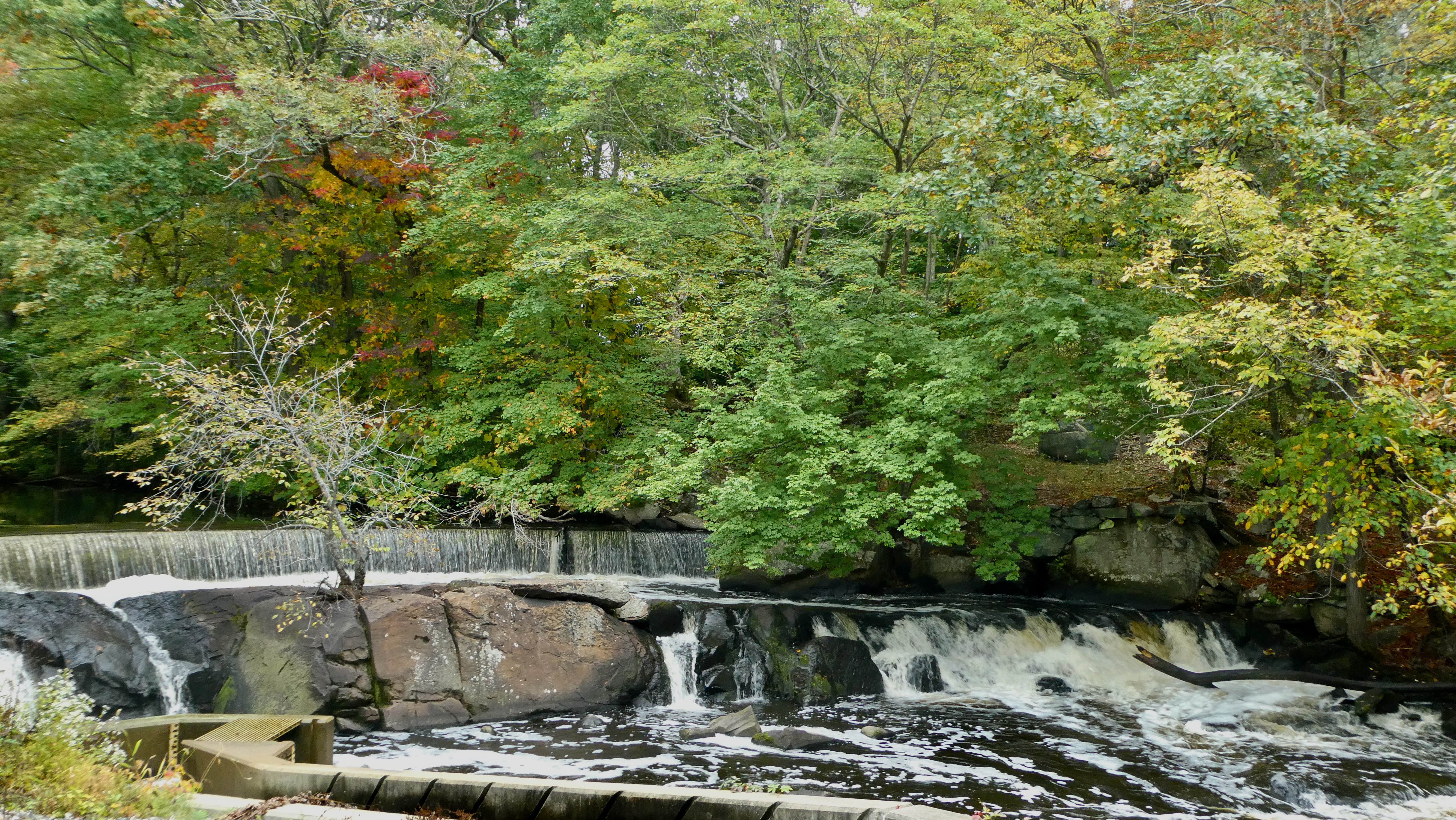
Adjacent the Hunt House as it stands today is where Stephen Payne built a sawmill, grist mill and tannery back in 1643 on the Ten Mile River. If you follow the River westward it forms the southern boundary of the approximately 300 acre of the Ring of Green. Whether this or any other of the numerous Mills along Ten Mile River may have been where Robert WHEATON’s Tannery was located we will never know.
We did have a fruitful meeting and later I spent an afternoon talking photos along Greenwood Ave and the ends of Pearl and Chauncey avenues trying to make sense of the original home lots as shown in the Volumes by John G Erhardt. Below you see his drawing of the Ring of Green. Which for those not in the know, is now in East Providence [Rumford], Rhode Island, for the original Rehoboth was not where it is today.
The Ring of Green

The homelots of the original proprietors of Rehoboth were laid out around a common or green. This area would be where livestock was allowed to graze and a meeting house/church would be built. Five gates were scattered about the green where you could enter or exit. The green was fenced and surrounded by house / farm lots of six, eight or twelve acres depending on the wealth of the proprietor. Rehoboth was the name chosen by Samuel Newman. To the native Narragansett and Wapanog, it was known as Seaconk or Seekonk. I will not wasde into the controversy over what Seekonk means as Richard LeBaron Bowen gives up the first 24 pages to an exploration in his Early Rehoboth Vol. 2.
In the map above the lots on the south of the Ring from Isaac Martin to Obadiah Holmes lay along what is now Greenwood Ave. The bottom parts of those lots are now part of the Agawam Hunt Golf Course. Sorting out what the lots were then and where they are today has been a major challenge. I have come up with many iterations of that map with lots superimposed onto a aerial view of Google maps of the present day. But it was never quite matching up. I worked on it many times since my visit and then set it aside.
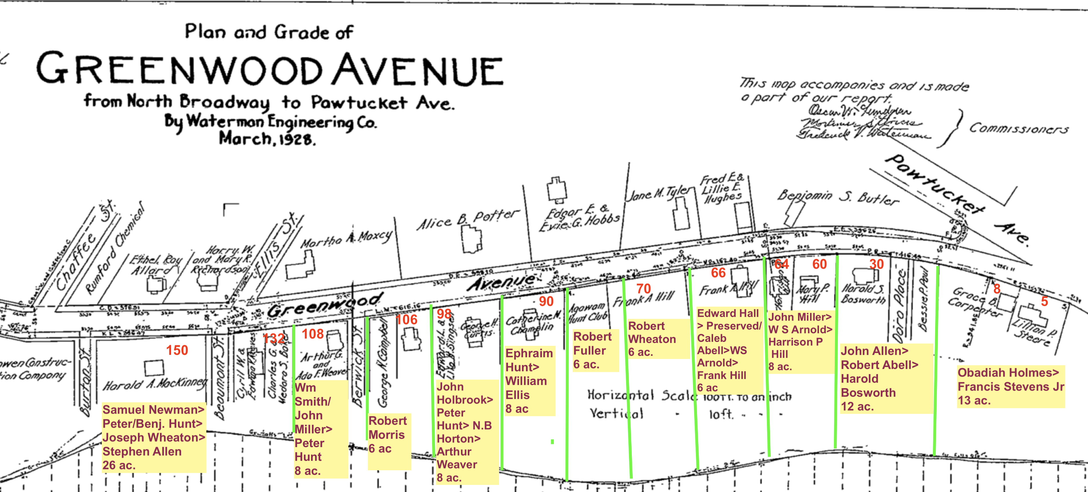
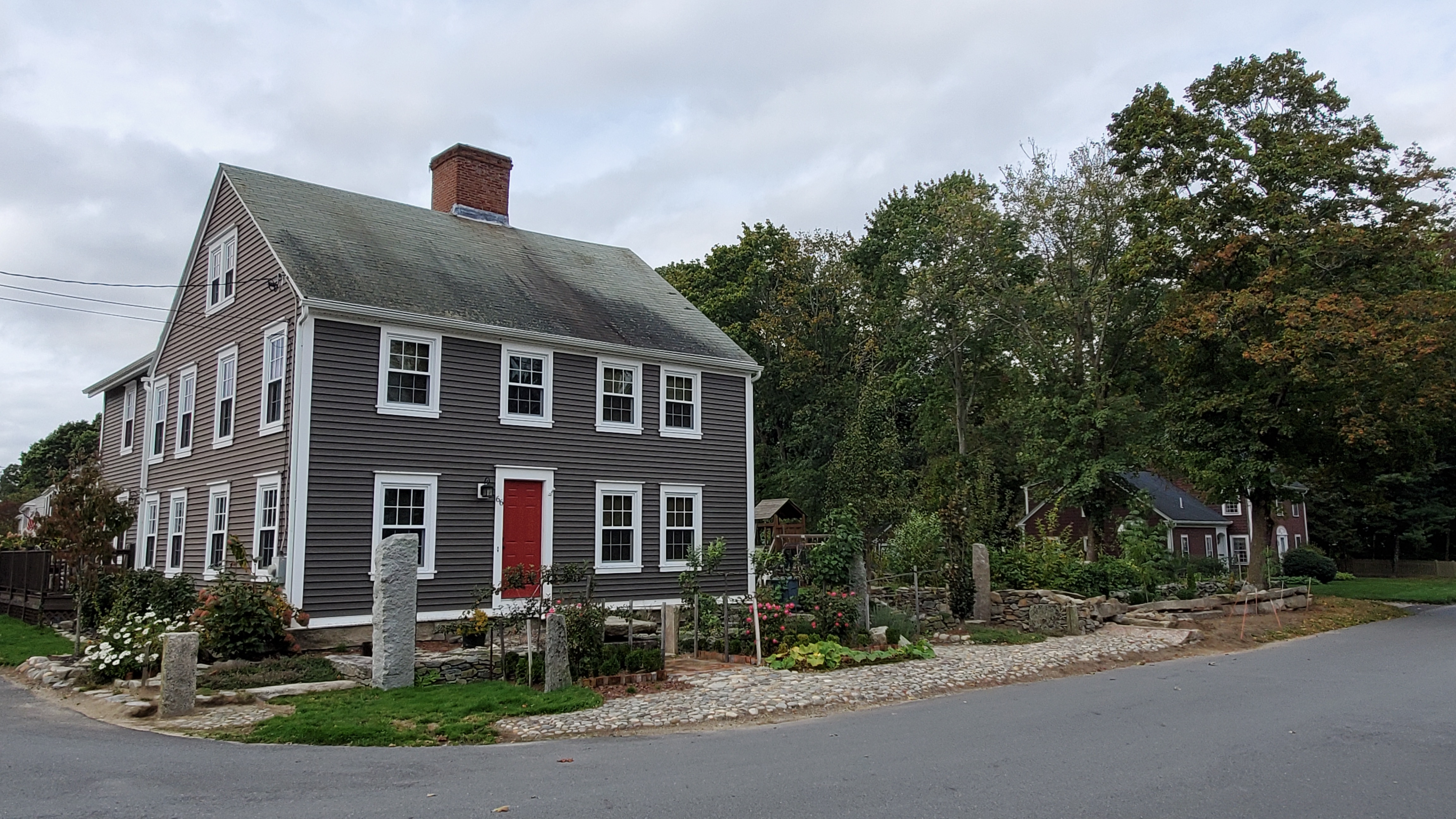
At the very beginning we knew the locations of Samuel NEWMAN’s lot but not all the area it encompassed. We know that the Phanuel BISHOP House at #150 Greenwood Ave was located on NEWMAN’s property. And we knew that the Caleb ABELL house is located at #66 Greenwood Ave and that another ABELL house is located at #30 Greenwood. But where exactly lay the lots of Robert WHEATON and his neighbor Robert FULLER were guestimates.
The Two Roberts: WHEATON & FULLER
The Puzzle
Then Sandra contacted me and we started working afresh. Although its still a work in progress its getting closer and closer. So if there were rudimentary surveying and property disputes back then—it wasn’t going to be easy to reconstruct the past. What is evident is that the separate, discrete lots of the original 1645 Ring of Green were consolidated over time and then more recently separated back again into smaller lots. The exact location of property lines is going at be suspect at best. But I am going to put forward what we have so far and amend it, as necessary.
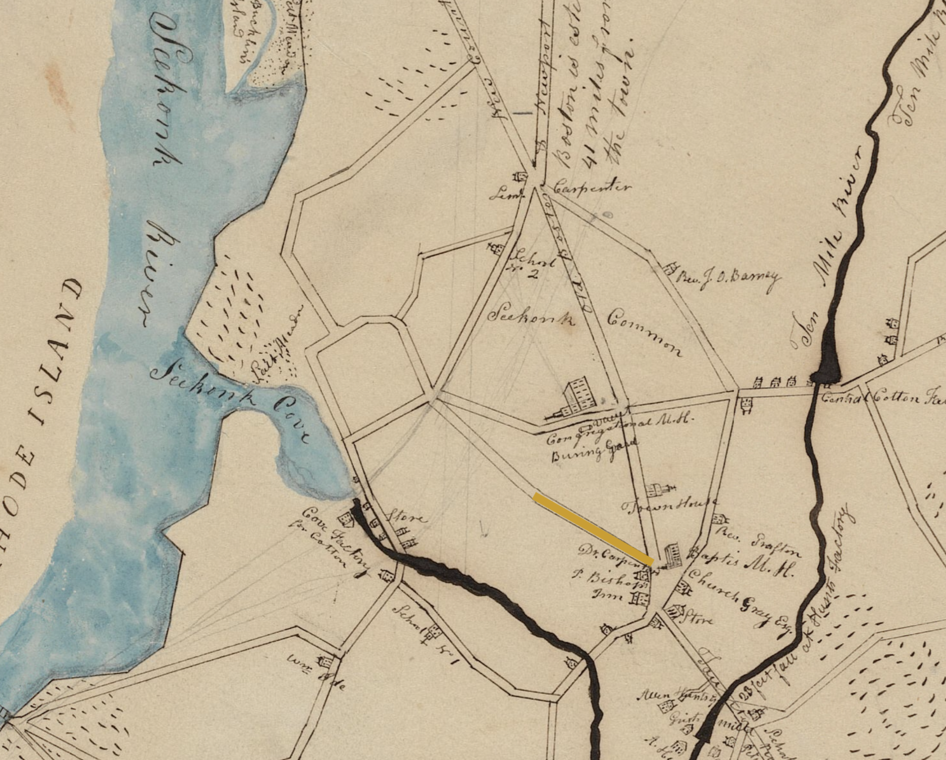
I have highlighted Greenwood Ave. Courtesy of Norman B. Leventhal Map & Education Center, Boston
So I decided to take another approach that led to this chart. As I said this is a work in progress. But I am confident it is close.

Plotting them onto a 1928 Map of Greenwood Avenue it looks like this.
Holmes, Abell & Allen Houses
I did not take photos of every lot but starting with #8 Here goes. This is the lot of Obadiah HOLMES. It is said that this house, built about 1760’s on the foundation of a house that burned during King Phillips War.

Next up is #30 originally John ALLEN and later Capt. Robert ABELL. Later known as the Harold BOSWORTH Hose built about 1910’s.
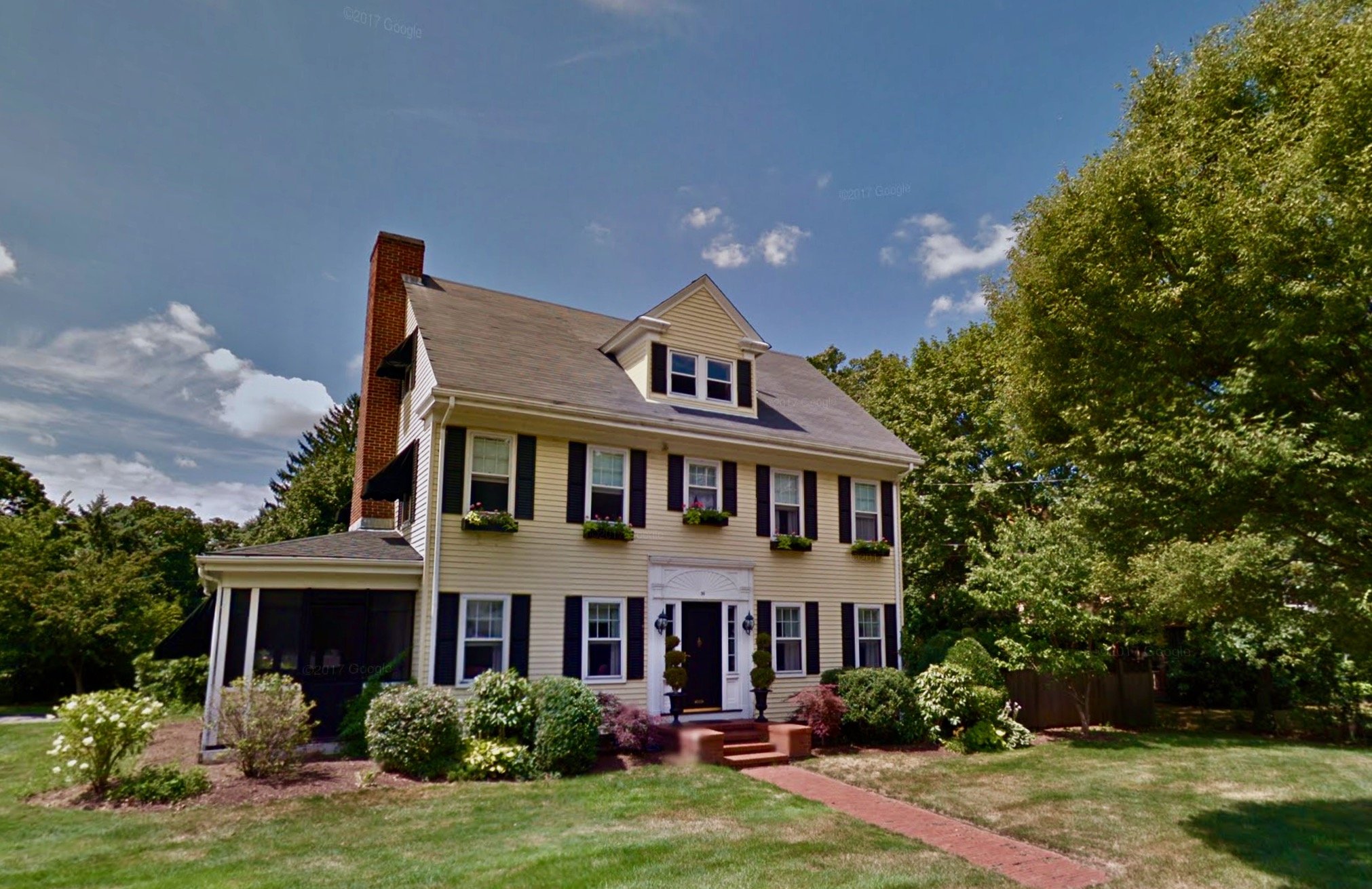
The following property was also owned at one time by the ABELL family. The original foundation goes back to the 17th century. The first house built in 1643 burned in 1676. The current house dates about 1750. The original lot belonged to Edward HALL then Caleb ABELL.
Robert Wheaton’s and Robert Fuller’s Lots
Both Robert WHEATON bc 1606 and Robert FULLER bc 1615 settled originally at Salem, Massachusetts. Robert WHEATON was a tanner and Robert FULLER a bricklayer or mason. Robert WHEATON appears on the records in Salem in 1636 and Robert FULLER in November of 1639. The Roberts each married sisters Alice and Sarah BOWEN, daughters of Richard BOWEN. It is most likely that Richard BOWEN was instrumental in the Roberts moving to Rehoboth as he was with the Rev. Newman at Weymouth, Massachusetts before relocating to Rehoboth. The border between Robert WHEATON’s property and Robert Fuller’s was in dispute for thirty years. Robert FULLER turned over his home lot to his son Benjamin in 1679, only after the property dispute was settled:
As a side note Sarah (BOWEN) FULLER wife of Robert FULLER died 14 October 1676, prehaps killed by Indians. That same year all but two houses on the Ring of the Green were burnt to the ground and Robert and Sarah’s sons Samuel and John FULLER were killed in August. It is presumed that their sister Abigail was also a victim of King Phillip’s War. It is perhaps for this reason Robert FULLER removes to Salem in 1676 where he lives with his new wife Margaret the widow of Christopher WALLER. In their 80’s Margaret and Robert FULLER return to Rehoboth. She dies in 1699 and he in 1706. By comparison Robert WHEATON’s family survive King Philips War intact. Robert died in 1696 in his 90th year, his wife Alice sometime between the time of the writing of his will in 1686 and the settlement of his estate in 1696. It is suggested that they are buried near their son, the Rev Ephraim WHEATON at Old Burial Hill but no markers exist. However there are some field stones in the general vicinity.
” An agreement made the 28th [torn] of 1679 Betwixt Robat Wheaton and Robert ffuller both of Rehoboth in order to make the ending of a contriversie that hath ben longe between them Respecting the Bounds of thire home lott, the said Robat Wheaton ingageing in the persone of Mr James Browne and other neighbors; that betwixt this day and winter sets in he would puk his fence and set it in the bounds where the thre stakes stands, and they both agreeingthat they both agreeing that those stakes shall be the bound between them: witness my hand the day and yeare above written, The Marke of Robert Wheaton. “ William Carpenter, Town Clerk Rehoboth Town Meetings Book II
So the answer to my quest is probably the same hunch I had when wandering up and down Greenwood Ave. It would be closest to the lot of #70 today. Of course the house there is much more recent.

To the right (west) is a wooded stream bisected lot that would have been Robert FULLER’s his house being located across Greenwood Ave on the North side where it is less steep. I suspect Hayward Place and this wooded area would be a part of his original lot.


View from the Backside to the South
All of these lots along Greenwood had their southern boundary at Ten Mile River. Their lots would have encompassed what is now the Agawam Country Club & Golf Course. So I also went to the south side and took photographs shooting northward.

I think it interesting to compare this view with one 100 years earlier.

Continuing Along Greenwood Ave
This House at #90 Greenwood Ave is known as the 1871 William W. ELLIS house. The house was altered in the 20th century. This is likely on what was the Ephraim HUNT lot back in 1645. The woods to the left side of photo would be that of Robert FULLER lot.

This house at #98 built in the 1860’s would be the approximate location of the John HOULBROKE lot.

That is Followed by the Nathaniel BISHOP House at #106 Greenwood Ave. This house built in the 1860’s by Nathaniel BISHOP on the approximate Robert MORRIS lot.

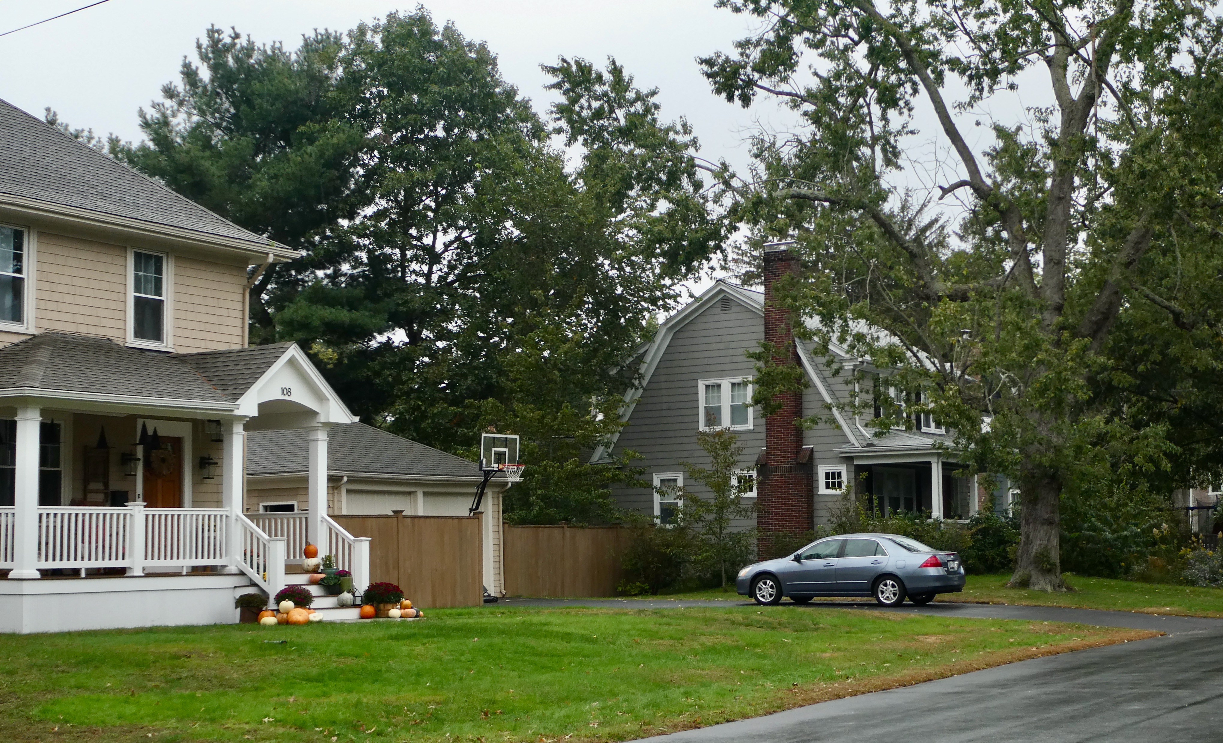
These two house at #108 and #132 were originally the William SMITH lot and Town Land lots. #132 was later consolidated into the holdings of Samuel NEWMAN. #108 is known as the Arthur WEAVER house built in the early 1900’s.
And finally we arrive at the Property originally belonging to Samuel NEWMAN known now as the Phanuel BISHOP house. It was built in the 1770’s .

Located on property previously owned by the Rev. Samuel NEWMAN
Further research may yield adjustments but I decided to publish this in the event someone has information that will further clarify what we think we know. Additions and corrections are always welcome. Thank you’s to Sandra Turgeon and Lende Mcmullen.
Note: Please if you visit this neighborhood be respectful of the people who live here. And don’t forget to pay your respects at Newman Cemetery which is what remains of the green, of the “Ring of Green.”

Kelly Wheaton ©2023 All Rights Reserved

Great detective work, I mean genealogical research. Good luck with your ‘ongoing investigation’!
Thank you!
Thank you so much for this. My grandparents build a house in the 1930’s at 111 Greenwood Avenue. I guess that was on the green side of the street. Across the street my mother made me aware of the historical homes, but I never understood exactly where the “green” was. I am descended from quite a few of these original settlers, so I think I will be heading back with your information to see what it looks like now. Again, thank you so much!
You are welcome! The Robert Fuller house was on the Green side!
Pingback: The Ring of the Green — Our Ancestors in Rehoboth – This is Our Family
Pingback: Friday’s Family History Finds | Empty Branches on the Family Tree
Thanks for including me.
We descend from Robert Abell and I believe Allens as well. I have always been drawn to Seekonk.
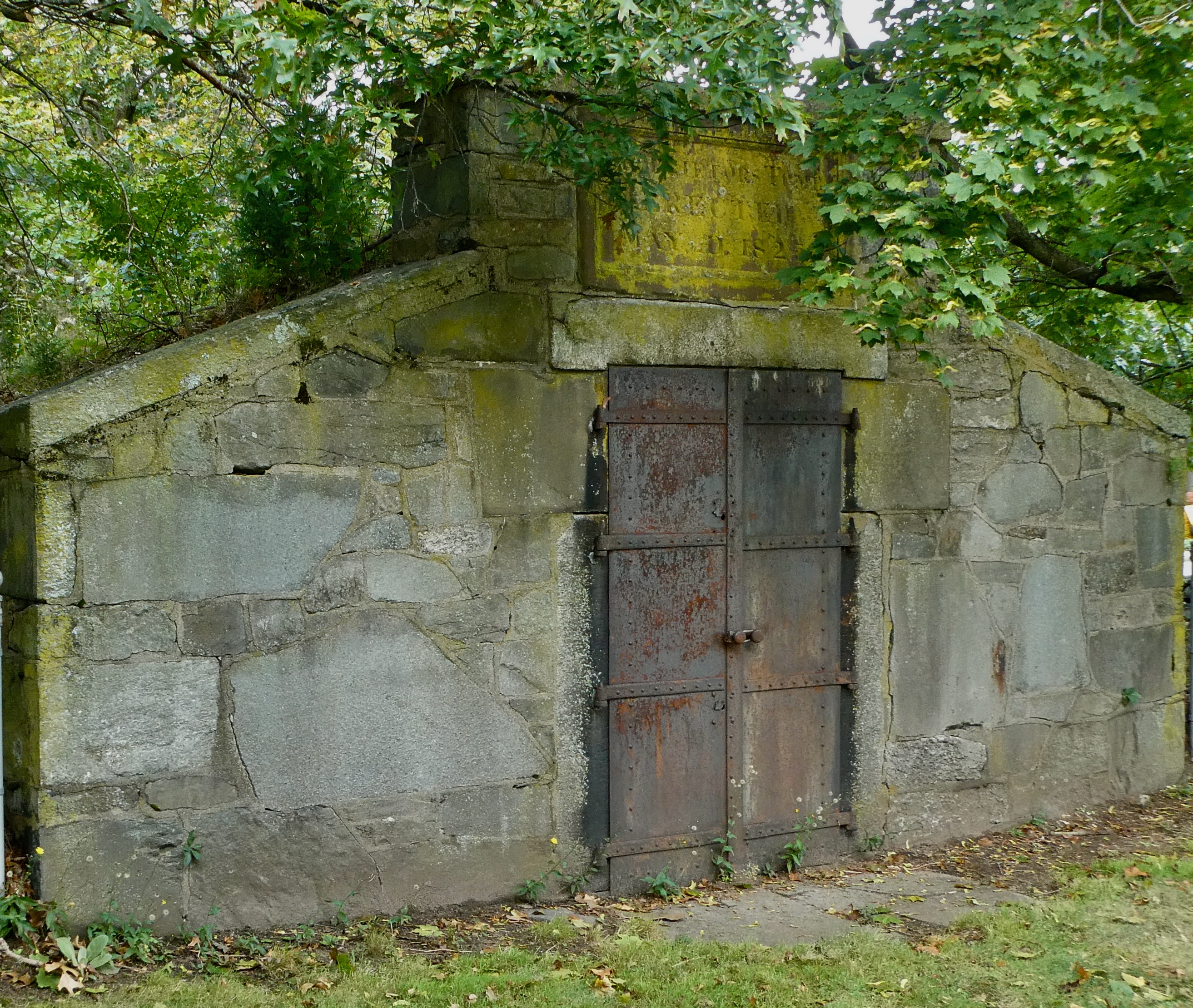
What is the structure in the last picture? Stone with iron doors?
That is the proprietor’s Tomb. Love to have them do a DNA analysis of the bones. Not sure if Robert WHEATON is interred there. More likely by field atones at Old Burial hill, near his son Ephraim’s grave.
This is fantastic! I have done the same thing that you have done by overlaying the current day map with the Ring of the Green map! But you did such a better job of finding today’s location. I did figure out that my 8th great grandfather’s property (Robert Fuller) was along the Ten Mile River and the Golf Course, but had no idea that it coincided wtih 80 Greenwood Road, so THANK YOU FOR THAT! One thing I am going to explore with the historical association is that when I put the Newman Center in my GPS to go visit today, it said Robert Fuller’s Town Meeting House. I know from some geneology research that my 8th Great grandfather either gave the money for the first meeting house OR he built it, now that his name is attached to it on my GPS tells me that must be true, BUT I have never seen his name attached to it and I’d like to know more about that. Thanks a million for confirming the locations, as best as you said they are believed to be true locations!
Thank you. Never quite sure I have it right. If further info comes to light I will revise.